common: lid_topic: "/livox/lidar" imu_topic: "/livox/imu" con_frame: false # true: if you need to combine several LiDAR frames into one con_frame_num: 1 # the number of frames combined cut_frame: false # true: if you need to cut one LiDAR frame into several subframes cut_frame_time_interval: 0.1 # should be integral fraction of 1 / LiDAR frequency time_lag_imu_to_lidar: 0.0 # Time offset between LiDAR and IMU calibrated by other algorithms, e.g., LI-Init (find in Readme) # the timesample of IMU is transferred from the current timeline to LiDAR's timeline by subtracting this value
preprocess: lidar_type: 1 scan_line: 4 timestamp_unit: 1 # the unit of time/t field in the PointCloud2 rostopic: 0-second, 1-milisecond, 2-microsecond, 3-nanosecond. blind: 0.5
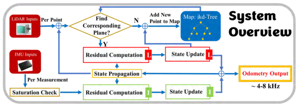
mapping: imu_en: true start_in_aggressive_motion: false # if true, a preknown gravity should be provided in following gravity_init extrinsic_est_en: false # for aggressive motion, set this variable false imu_time_inte: 0.005 # = 1 / frequency of IMU satu_acc: 3.0 # the saturation value of IMU's acceleration. not related to the units satu_gyro: 35 # the saturation value of IMU's angular velocity. not related to the units acc_norm: 1.0 # 1.0 for g as unit, 9.81 for m/s^2 as unit of the IMU's acceleration lidar_meas_cov: 0.001 # 0.001; 0.01 acc_cov_output: 500 gyr_cov_output: 1000 b_acc_cov: 0.0001 b_gyr_cov: 0.0001 imu_meas_acc_cov: 0.1 #0.1 # 0.1 imu_meas_omg_cov: 0.1 #0.01 # 0.1 gyr_cov_input: 0.01 # for IMU as input model acc_cov_input: 0.1 # for IMU as input model plane_thr: 0.1 # 0.05, the threshold for plane criteria, the smaller, the flatter a plane match_s: 81 fov_degree: 360 det_range: 100 gravity_align: true # true to align the z axis of world frame with the direction of gravity, and the gravity direction should be specified below gravity: [0.0, 0.0, -9.810] # [0.0, 9.810, 0.0] # gravity to be aligned gravity_init: [0.0, 0.0, -9.810] # [0.0, 9.810, 0.0] # # preknown gravity in the first IMU body frame, use when imu_en is false or start from a non-stationary state extrinsic_T: [ -0.011, -0.02329, 0.04412 ] extrinsic_R: [ 1, 0, 0, 0, 1, 0, 0, 0, 1 ]
publish: path_en: true # false: close the path output scan_publish_en: true # false: close all the point cloud output scan_bodyframe_pub_en: false # true: output the point cloud scans in IMU-body-frame
pcd_save: pcd_save_en: false interval: -1 # how many LiDAR frames saved in each pcd file; # -1 : all frames will be saved in ONE pcd file, may lead to memory crash when having too much frames.
publish: path_publish_en: false scan_publish_en: true # false: close all the point cloud output scan_effect_pub_en: true # true: publish the pointscloud of effect point dense_publish_en: false # false: low down the points number in a global-frame point clouds scan. scan_bodyframe_pub_en: true # true: output the point cloud scans in IMU-body-frame
path_save_en: true # 保存轨迹,用于精度计算和比较
pcd_save: pcd_save_en: true interval: -1 # how many LiDAR frames saved in each pcd file; # -1 : all frames will be saved in ONE pcd file, may lead to memory crash when having too much frames.